

")


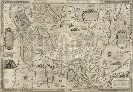
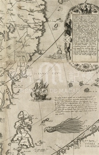
Abraham Ortelius was born in Antwerp, and was one of the top European cartographers in the sixteenth century. In 1570 Ortelius made the first world atlas Theatrum Orbis Terrarum, which includes the map named Asiae Nova Descriptio with a far-reaching effect. This one sheet map named Asiae orbis partium maximae nova descriptio was also produced by Ortelius in 1567, and was the original version of the map in his atlas. The drawing of China on this map is similar with the map of Asia by Italian cartographer Giacomo Gastaldi in 1559. The coastline of China extends from southwest to northeast on the whole. The regional names of places on this map are from the ancient and 'modern' geographical knowledge of that time. 'China Pro.' is noted near the tropic of cancer, and 'Cheqvan Regi', 'Nanqvi Regi', 'Xanton Regi', 'Qvinci Regi' are noted on the coastland. 'Cataio Pro.' and 'Mangi Pro.' are noted on the inland region. The Pearl River estuary is shaped as a widen strip, 'Guanzu' is noted on the top of the estuary, and 'Cantõ' on the south part of its eastern shore, and both of them indicate Guangzhou. 'Nanto' is noted to the southeast of Cantõ. To the east of the Pearl River there is another small river flows into the sea. 'Matan' is noted on the east side of its estuary. Out of the Pearl River estuary, a group of small islands are drawn to the west, beside of which is the Latin note 'Hic filius mar garitas producit', which is the explanation of the name of the Pearl River. We can also find the small islands and note on Gastaldi's map.
Reference:
[1]. Ristow, W. W. (1970). Theatrum Orbis Terrarum 1570-1970. The Quarterly Journal of the Library of Congress, 27(4), 316–331.
Informações relevantes
Data de atualização: 2020/09/08
*Este mapa histórico destina-se exclusivamente a fins de referência académica e de investigação, não tendo qualquer validade oficial ou legal.
Comentários
Comentários (0 participação(ões), 0 comentário(s)): agradecemos que partilhasse os seus materiais e histórias (dentro de 150 palavras).