

")


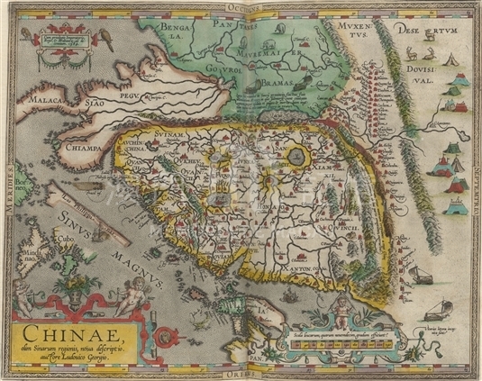
Made by Portuguese Jesuits Luiz Jorge de Barbuda, this map was first printed on the Latin version of Theatrum Orbis Terrarum published in 1584 and was reprinted continuously. It is the earliest known Map of China made on one single map by Europeans so far. On the map, West points up, East points down, North points right and South points left. The landscape of China is like a rectangle, the coastline from northern areas to Zhejiang province was wrongly drawn as a north-south straight line, while the coastline of from Fujian province to Guangdong province was relatively correct, which was drawn as a slash from north to south. The most prominent feature of this map is that the names of two capitals and thirteen provinces of Ming Dynasty were thoroughly marked on the map for the first time, and the outdated old place names were no longer used. On the right part of the map (Northern area), there is not only clearly marked Great Wall but also textual description. 'Macoa' was recorded on the east coast of the Pearl River. The description of the river system in China was full of mistakes, showing that Europeans had little knowledge of Chinese inland regions at that time. On the rightmost part of the map is MoBei grasslands, on which stage and large area of tents were drawn. Four four-wheeled wind vehicles drawn around China were also from the imagination of the mapmaker.
It is copied from Theatrum Orbis Terrarum (1605, English edition) from Harvard University Library.(MO 1.1606 pf).
Reference:
[1]. Ortelius, A. (1606). Theatrum orbis terrarum Abrahami Orteli Antverp : The theatre of the whole world. London: Iohn Norton.
[2]. Cortesão, A. (1960). Portugaliae monumenta cartographica (Vol. II, 123-5). Lisboa.
[3]. 黃時鑒. (2008). 巴布達《中國新圖》的刊本、圖形和內容. 文化雜誌, 夏季刊.
Anotações: [Theatrum Orbis Terrarum (Latin) ], 1584.
Informações relevantes
Data de atualização: 2020/09/09

Comentários
Comentários (0 participação(ões), 0 comentário(s)): agradecemos que partilhasse os seus materiais e histórias (dentro de 150 palavras).