

")


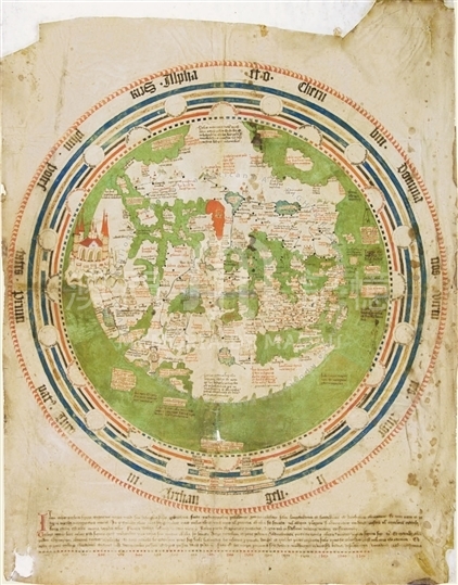
Andrea Walsperger was a Benedictine monk from Salzburg, who made this planisphere in Constance, Germany. With a diameter of 57.5cm, the planisphere is surrounded by circles representing the heavenly spheres and the 'heaven of crystal.' It is oriented to the South and Jerusalem is placed at the center of the world sphere. The earth is surrounded by an ocean except at the far South, and at the top of the map, where Africa stretches to the edge of the circle. To the East, left on the chart, where the earthly Paradise is established as a city with towers and walls, are the sources of the rivers of Paradise: the Pison, Tigris, Euphrates and Gichon. Africa and Asia are so close that they are separated only by a forked strait. A red dot marks each city controlled by Christians; while pagan-ruled cities are marked with a black dot. A red dot is found on Taprobana and the island where St. Thomas the Apostle is thought to be buried, while another one marks the stone tower on the narrow land bridge to East Asia. As noticed by Almagià, the singularity of this map is that the whole of East Asia is almost separated from the rest of the Central Western Europe-Asia landmass. This late medieval planisphere represents a transitional type of cartography that was beginning to develop in Western Europe before the Renaissance reflecting the influence of Claudius Ptolemy's Geographia , which appeared after the introduction and translation of this work in the early 15th century. Legends of late medieval toponyms, such as 'Qinzai' (行在,today 杭州); 'Kataya imperium'; 'Tartaria imperium'; and the capital city Sara, 'Saraa caput Tartarorum ubi imperator moratur' (Saraa, the capital of the Tartars, where the emperor resides); and 'Waldach civitas kathay ubi magnum cham moratur' (Waldach, the city of Cathay, where the Great Khan resides) adorn the map. In South and Southeast Asia, there are the following descrptions: 'Taprobana, ortus piperis' (Taprobana, rose pepper); 'Aurea Chersonesus' (golden peninsula).
Reference:
[1]. ALMAGIÀ, R. (1944). Planisferi, carte nautiche e affini dal secolo XIV al XVII esistenti nella Biblioteca Apostolica Vaticana. In Monumenta cartographica Vaticana (vol.1, pp. 30-31). Città del Vaticano.
[2]. SIEBOLD, J. (2015). Cartographic Images. Retrieved from http://cartographic-images.net
[3]. Arnaud, P. (1995). Images et représentations dans la cartographie du bas Moyen Âge. In Spazi, tempi, misure e percorsi nell'Europa del bassomedioevo. Atti del XXXII Convegno storico internazionale, Todi 8-11 ott. pp. 137, 150, fig. 5.
[4]. Gautier Dalché, P. (1996). Pour une histoire du regard géographique: Conception et usage de la carte au XVe siècle. In Micrologus. Rivista della Società internazionale per lo studio del Medioevo latino, 4, p.94.
[5]. Mutafian, C. (1999). Andrea Walsperger - 'Mappa Mundi (1448).' In Roma - Armenia [catalogo di mostra, Città del Vaticano, Salone Sistino, Biblioteca Apostolica Vaticana, 25 marzo-16 luglio 1999], p. 27.
[6]. Dumitriu-Snagov, I. (1985). Marea Valahie si Transilvania in Mapamondul Borgian' de la inceputul secolului al XV-lea. In Revista Arhivelor, 47, p.259.
Informações relevantes
Data de atualização: 2020/09/08

Comentários
Comentários (0 participação(ões), 0 comentário(s)): agradecemos que partilhasse os seus materiais e histórias (dentro de 150 palavras).