

")


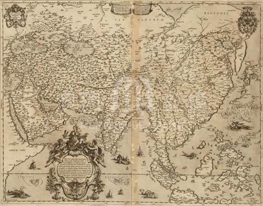
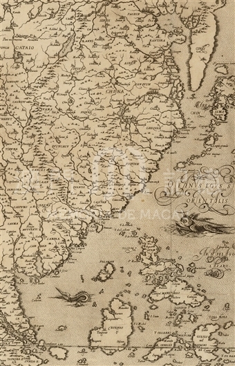
The cartographer of this map is Fausto Rughesi who was well-connected and based in Rome. The extension, outline and drawing style of this map is similar to that of Ortelius's Asiae Nova Descriptio, so the latter should have some influence on this map. Nevertheless when look carefully into the part of China on this map, we can find that it is drawn after consulting many old and late European maps in correlation with China. The coastline of China south of the C. Liampo generally looks like that on the Ortelius's map, when the northern part of coastline is of great difference. The Shandong peninsula, Korean peninsula, and west half of Japan on the map is approximately correct. And there is the figure of the wandering Great Wall on the north part of China. The names of the provinces of China are written according to the Barbuda's Chinae, olim sinarum regionis, nova descriptio in the 1584 edition of Ortelius's Theatrum Orbis Terrarum. The coastline of north China, especially that of the Shandong peninsula is very similar to Michele Ruggieri's manuscript Atlante della Cina. The mapmaker drew the rivers and lakes inland by synthesizing the maps of Ortelius, Barbuda, Ruggieri, and probably someone else. The Fu (Prefecture) cities are drawn on the map, and the origin of data is worthy of studying, some of them origin from Ruggieri's manuscript. Since Ruggieri's manuscript was drawn during the first years of the 17th century, this map of Rughesi was surely made after that time. The shape of the Pearl River estuary in the province of Cantan is similar to Ortelius's Asiae Nova Descriptio, the estuary looks like a widen strip, and flows southeastward to the sea. The city of Cantan is located on the northeast of the estuary, and there is a note of 'Lampacao' near the exit of the eastern coast of the estuary. To the futher southeast writes 'Lantao', and both notes are noted in the sea. To the east of the estuary is another small river. On the east side of the river, 'Matan ci' is noted near the exit, and the 'ci' probably means city. The position of the note of 'Matan' is similar to that on Ortelius's map.
Reference:
[1]. Ruggieri, M.; 金國平譯. (2013). 大明國圖志:羅明堅中國地圖集. 澳門: 澳門特別行政區政府文化局.
[2]. ALMAGIÀ, R. (1944). Planisferi, carte nautiche e affini dal secoli XIV al XVII esistenti nella Biblioteca Apostolica Vaticana. In Monumenta cartographica vaticana (vol.1, pp.69-74, XXII). Città del Vaticano.
[3]. M. Fiorini. (1891). Il mappamondo di Fausto Rughesi. Bollettino della Società Geografica Italiana, 956-972.
Informações relevantes
Data de atualização: 2020/09/08
Comentários
Comentários (0 participação(ões), 0 comentário(s)): agradecemos que partilhasse os seus materiais e histórias (dentro de 150 palavras).