

")


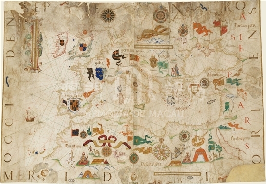
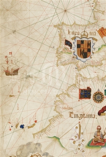
This is a large nautical map painted in color on parchment, measuring approximately 73 x 107 cm. It covers the entire Mediterranean and Black Seas, the Western coasts of Africa until C. do boiador with the Canaries and Madeira, the Atlantic coasts of Europe with the British Isles, the Danish peninsula, a piece of Scandinavian coasts and the Western part of the Baltic Sea. Denmark and the southern strip of Scandinavia have no coastal names. The map's coastlines are rimmed with gold; islands are depicted in various colors (blue, red, gold); coastal names are depicted in black and red. The map has a very fine representation of the coasts and a very rich topography with many details. Italy is in the center of the map. A central rose of 32 winds, with the coat of arms of Pope Pius V (1566-1572), is painted to the northeast of Rome. The map is full of decorative elements. There are great prospects of some cities: like Genoa, Venice, Jerusalem, Lisbon (topped with flags), two cities in Africa (one of them is Tunis, the other probably Morocco), and one in Hungary. The big flags and showy coats of arms are relevant to the sovereigns of single countries; while two figures represent the sovereigns of Africa, with tents, camels, etc. In the Atlantic there is a beautiful drawing of a caravel. Along the four edges of the map, in large letters, there are the names of the four cardinal points and eight heads of cherubs representing the eight main winds. The names Europe and Africa are depicted in large fluttering ribbons, and on the right strip 'ASIAE PARS' is written, along with a few other regional names (Gallia , Flandria, etc.). The map also depicts a few mountains in light green. Unfortunately, the map is quite damaged, with many traces of moisture and two tears at the top left and bottom right. It was repaired by reinforcing the parchment. The tear at the bottom right has removed the signature of the cartographer, with only the word 'Diegu[s]' remaining. A specimen of a map by Homen in the National Library of Florence signed as 'Diegus Homě cosmographus fecit anus dňi 1563', has the same framing and coastal designs, with only very slight differences in coastal place names, and the same decorative characteristics. There are other copies of this map signed with different dates. The map was later reprinted in different editions between 1569 and 1606. The activity of the Portuguese cartographer Diogo Homen was limited to between the years 1557 and 1576. Even though maps prior to 1568 do not bear indications of where they were manufactured; we know that from 1568 to 1576 all his known maps were made in Venice. This map was obviously intended as a gift to the pope.
Reference:
[1]. ALMAGIÀ, R. (1944). Planisferi, carte nautiche e affini dal secolo XIV al XVII esistenti nella Biblioteca Apostolica Vaticana. In Monumenta cartographica Vaticana (vol.1, p. 76). Città del Vaticano.
Informações relevantes
Data de atualização: 2020/09/08
Comentários
Comentários (0 participação(ões), 0 comentário(s)): agradecemos que partilhasse os seus materiais e histórias (dentro de 150 palavras).