

")


Giulio Aleni, an Italian Jesuit, arrived in Macao via Goa of India in 1610 and later came to mainland China in 1613. He did missionary work in several cities like Beijing, Kaifeng, Nanjing, Hangzhou and in Fujian Province. He helped build as many as 20 churches and baptized more than 10,000 people, so he was praised as the 'western Confucius' by local Christians.
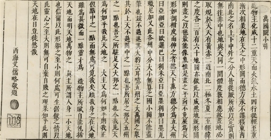
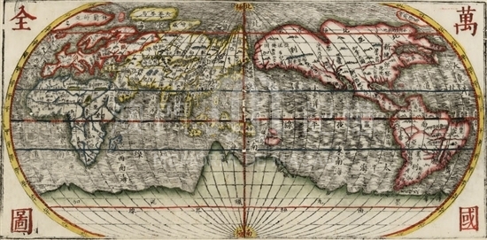
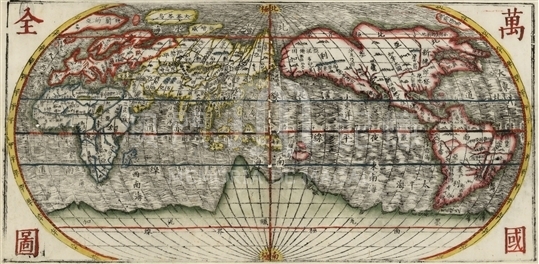
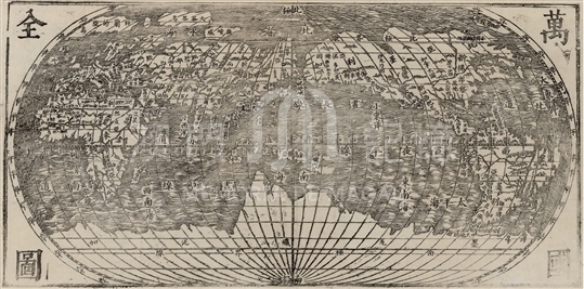
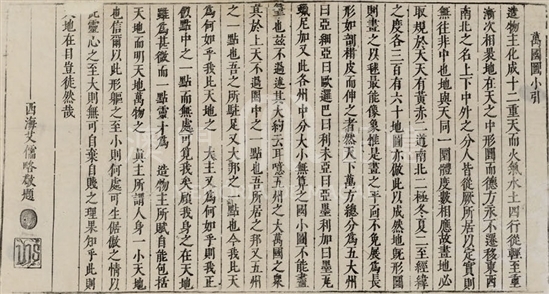
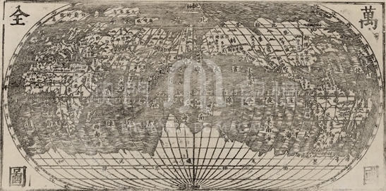
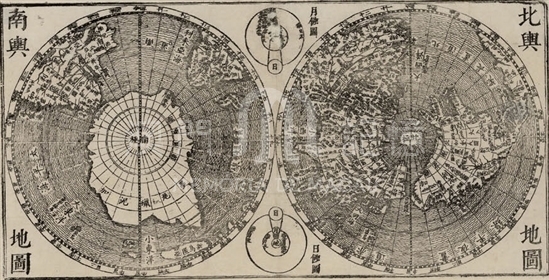
When he was in Hangzhou city in 1623, Giulio Aleni studied Abraham Ortelius's Theatrum Orbis Terrarum and the works from Diego de Pantoja and Sabatino de Ursis, and then made Wan Guo Quan Tu (Map of the world) and compiled it to the book of Zhifang Waiji (Chronicle of Foreign Lands). The map was constantly reprinted and spread in varied versions. There are both monochrome and colored versions in Vatican Library, hereinafter referred as Version A and Version B, according to the shelfmarks. Version B consists of three parts in monochrome ink, with the first part as introduction, the middle part as Wan Guo Quan Tu, and the final part as two hemisphere maps of Bei Yu Di Tu (Map of the North) and Nan Yu Di Tu (Map of the South). While Version A covers the ink monochrome with colors, but removes the two hemisphere maps, with the introduction part and the final part left. Aleni employed Chinese conceptions of size and varied layers of 'Heaven' in order to elaborate geographical concepts and Catholic doctrines, with an attempt of breaking up the stereotypes of imperial centralism, and thus inspiring and establishing a new outlook of world among scholar officials in late Ming Dynasty.
In addition to the names of the fifteen provinces, it is also included the four Chinese characters, '大清一統' (Da Qing Yi Tong , means unification of Qing Dynasty) on the inland places of the both versions. These four characters might prove the year of 1648 as a transitional period, when the army of Qing Dynasty established themselves in Fujian Province, and in the second year Aleni died. Interestingly contradicted, the two marine sections was both marked as '大明海'(Da Ming Hai, Sea of Ming Dynasty). In Bei Yu Di Tu (Map of the North) of version B, “大明一統' (Da Ming Yi Tong, unification of Ming Dynasty) was in the inland place, and Da Ming Hai in the ocean part. It thus could be presumed this engraved versions of Ming Dynasty were still in use in the early Qing Dynasty, being only partially modified.
Reference:
[1]. 黄时鉴. (2011). 艾儒略《萬国全图》AB 二本见读後记. 黄时鉴文集3:东海西海, 东西文化交流史(大航海时代以来). 中西书局,
273-280.
[2]. 邹振环. (2011). 晚明汉文西学经典 编译、诠释、流传与影响. 上海:复旦大学出版社, 255-288.
Informações relevantes
Data de atualização: 2020/09/08


")
")
Comentários
Comentários (0 participação(ões), 0 comentário(s)): agradecemos que partilhasse os seus materiais e histórias (dentro de 150 palavras).