

")


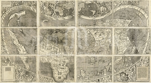
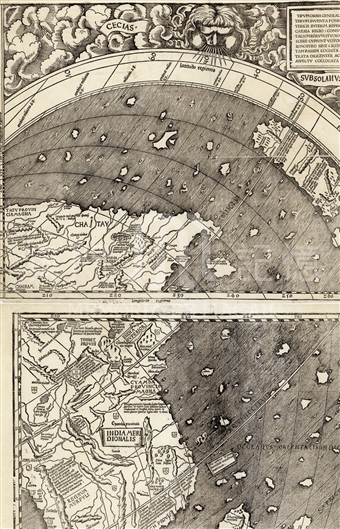
Found in Germany in 1901, the atlas contains 12 small maps, with the overall size of 132x236cm. It was made by German Catholicmonk Martin Waldseemüller(1470-1519) in Saint-Dié that was then ruled by Holy Roman Empire and now belongs to France. The whole map includes the upper part and the lower part. On the left side of the upper part was the portrait of the ancient Greek geographer Ptolemy and on the right side was the portrait of Amerigo Vespucci (1454—1512). Between the two lies a smaller world map, while the lower part of is of a heart-shape. For it is the earliest large world map with the country of America marked, Americans attach great importance to it. In 1903, Library of Congress in US acquired its copy, and later in 2003, they decided to pay ten million US dollars for the original map. The knowledge of Southeast Asia on this map was mainly acquired from the medieval works of Marco Polo et al. And the name of China was still marked confusedly as 'Chatay' and 'Mangi,' without new geographic knowledge added.
It is copied from the Library of Congress (G3200 1507 .W3 Vault)
Reference:
[1]. Shirley, R. (1983). The mapping of the world : Early printed world maps, 1472-1700. London: Holland Press. pp. 28-31.
[2]. Library of Congress. (2003-06-18). Library Completes Purchase of Waldseemüller Map. News from the Library of Congress. Retrieved from http://www.loc.gov/today/pr/2003/03-110.html
[3]. 龔纓晏. (2009). 亞美利哥:美洲以他命名.地圖,01期。
Informações relevantes
Data de atualização: 2020/09/09

Comentários
Comentários (0 participação(ões), 0 comentário(s)): agradecemos que partilhasse os seus materiais e histórias (dentro de 150 palavras).