

")


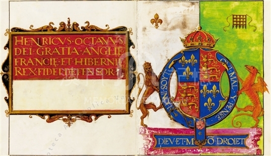
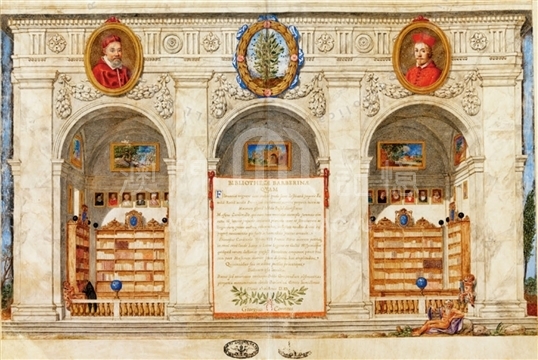
This is an atlas of ten maps painted in color on parchment, bound in volume with wooden slats and covered with red velvet, on which is impressed in gold the bee, symbol of the Barberini Family. The volume measures ca.27.5 x 21.5cm; the maps are double-sided and measure 21.8 x 35. 5cm; each of the maps is squared with a black line leaving a wide margin. The codex contains fifteen parchment sheets. The first one is blank on the recto side, and on the verso side it contains the following legend, in golden letters on a carmine background, inside the finely decorated cartouche: 'Henricus octavus dei gratia Angliae, Franciae et Hiberniae rex fidei defensor.' The second sheet has on the recto side the finely miniated coat of arms of Henry VIII, and on the verso side a table of declinations. The third sheet has on the recto side an armillary sphere. On the verso side of the third and on the recto of the fourth sheet, there is a zodiacal calendar with elegantly miniated zodiac signs, at the and at the center a small globe. The ff. 4v-14r are maps. On ff. 14v-15r, which were originally blank, a thinner parchment containing a finely delineated and colored large drawing of the Barberini Library was pasted. Underneath this there is a long dedication in golden letters signed by Georgius Conneus, who with this dedication offers the atlas to the Barberini Family. In the bottom right, there is also the name of the painter of this miniature: 'F. Lod. Galian[us]'.
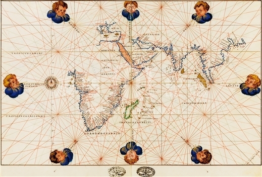
The atlas is a typical work from Agnese's Laboratory, even if it does not bear the name of the author. It should have belonged to Henry VIII (1509-1547), then was bound as we see it now, and given to Francesco Barberini. The donor George Conn was a well-known Scottish Catholic priest, who was in Rome from 1623 in the service of Cardinal Montalto, before beginning his service to Francesco Barberini. The maps of the atlas are: 1) The New World and the Pacific Ocean; 2) The New World, the Atlantic Ocean and Africa; 3) The Indian Ocean; 4) A Chorographical map of Central Europe; 5) The Iberian Peninsula; 6) The Western Mediterranean; 7) The Central Mediterranean; 8) The Oriental Mediterranean; 9) The Black Sea and Sea of Marmara; 10) An oval planisphere. On the map of the Indian Ocean, are represented the coastlines of Africa (starting with Guinea) and Southern and Eastern Asia, until agoa de paneicoda (?). 'China' is written in red, and close to it other several China coastal names in black, including 'rio di canton'.
Reference:
[1]. ALMAGIÀ, R. (1944). Planisferi, carte nautiche e affini dal secolo XIV al XVII esistenti nella Biblioteca Apostolica Vaticana. In Monumenta cartographica Vaticana (vol.1, pp. 68-69). Città del Vaticano.
[2]. Pásztor, L. (1970). Biblioteca Apostolica Vaticana. In Guida delle fonti per la storia dell'America Latina negli archivi della Santa Sede e negli archivi ecclesiastici d'Italia. In Collectanea Archivi Vaticani (vol.2, p.598). Città del Vaticano.
Informações relevantes
Data de atualização: 2020/09/08


Comentários
Comentários (0 participação(ões), 0 comentário(s)): agradecemos que partilhasse os seus materiais e histórias (dentro de 150 palavras).