

")


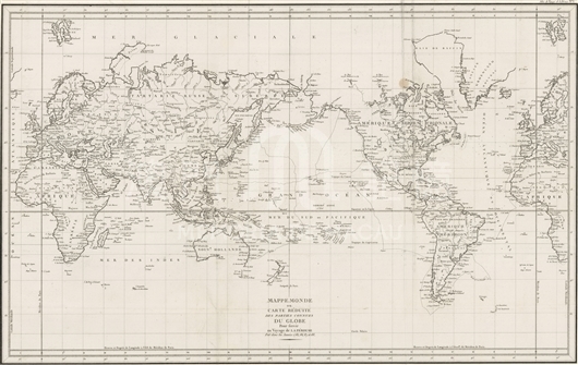
La Pérouse, a famous French navigator, who was ordered by French king, led his two large ships “La Boussole” and “L'Astrolabe” into the Pacific Ocean to conduct overall scientific research. They started from Brest, France, sailed across the Atlantic Ocean to Brazil, and then rounded Cape Hope into Pacific Ocean from east to west. After La Pérouse explored Alaska and a few other places, he decided to set out from Monterey in North America to cross Pacific Ocean and after a three-months voyage finally arrived at Macau on January 3rd, 1787. He stayed there over 5 months exploring the coastal areas in south Asia. Kamchatka was their last destination, where La Pérouse handed over all his logs, exploration records and maps to his mate, Barthélemy de Lesseps, asking him to take them back to Paris. The man passed through the landmass Eurasia and returned to France by land. While La Pérouse led his ships southward and reached Australia in January, 1788. Again he entrusted some Britons there to take his logs to Europe. Fortunately, large sums of files accumulated in his voyages were sent back to France. In March 1788, La Pérouse left Australia for surrounding investigations, but never returned. No one knew where he was. In 1797, Paris collected and published “Voyage de La Pérouse autour du monde” and “Atlas du Voyage de La Pérouse”. The map is the first piece of the Atlas, on which Pérouse’s navigation routes are clearly drawn, and land routes Lessepe adopted to cross Eurasia as well. On the map, China’s coastlines are precisely depicted, especially the description of projecting Shandong Peninsula, which almost perfectly outlines the shape of Bohai Sea. And also accurate is the shape of Pearl River Estuary in that not only several islands are drawn but Macau is also marked out as “Macao”. La Pérouse’s sailing routes, including the start point in North America, east-to-west direction crossing Pacific Ocean and the landing place, Macau, extending to west coast of Pacific Ocean, exhibit a vivid image of Macau’s status, an interchange in global routes.
This map is a copy of “G3200 1797 .L3 oversize”, the first piece of Atlas du Voyage de La Pérouse, preserved in the Library of Harvard University now, which were later drawn by an anonymous author based on collections from Pérouse’s materials.
Reference:
[1]. The Journal of Jean-Francois de Galaup de la Perouse, 1785-1788. volume 1-2. (1994). London: Hakluyt Society.
[2]. King, R. J. (2008). William Bolts and the Austrian Origins of the Lapérouse Expedition. Terrae Incognitae, 40, 1, 1.

Informações relevantes
Data de atualização: 2020/09/09

Comentários
Comentários (0 participação(ões), 0 comentário(s)): agradecemos que partilhasse os seus materiais e histórias (dentro de 150 palavras).